Geologic Map CartoScripts
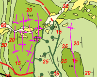
To illustrate the power of CartoScripts, MicroImages has created a set of free scripts designed to render the specialized line and point symbols for geologic and geotectonic maps.
More Style by Script pages:
Basic Style Scripts
CartoScripts
More CartoScript documentation and examples
The scripts set the size of point symbols and line elements in millimeters relative to the scale of the printed map. You can edit the scripts to set the desired map scale, element sizes, and color. Since these scripts use many of the CartoScript functions in varied combinations, you can also study them for ideas on how to create your own custom map symbols.
Fold Axis Lines
 download foldlines.zip
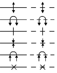
| Solid | Dashed | |
| Anticline | anticln1.qry | anticln2.qry |
| Overturned Anticline | anticln3.qry | anticln4.qry |
| Anticline (alternate) | anticln5.qry | anticln6.qry |
| Syncline | synclin1.qry | synclin2.qry |
| Overturned Syncline | synclin3.qry | synclin4.qry |
| Syncline (alternate) | synclin5.qry | synclin6.qry |
Fold Axis Lines 2
 download folds2.zip
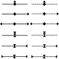
| Solid | Dashed | |
| Asymmetric Anticline | anticlnAsym1.qry | anticlnAsym2.qry |
| Plunging Anticline | anticlnPlng1.qry | anticlnPlng2.qry |
| Doubly-Plunging Anticline | anticlnDoubPlng1.qry | anticlnDoubPlng2.qry |
| Asymmetric Syncline | synclnAsym1.qry | synclnAsym2.qry |
| Plunging Syncline | synclnPlng1.qry | synclnPlng2.qry |
| Doubly-Plunging Syncline | synclnDoubPlng1.qry | synclnDoubPlng2.qry |
Fault Lines
 download faultlines.zip
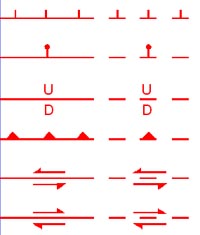
| Solid | Dashed | |
| Normal | normflt1.qry | normflt2.qry |
| Normal (alternate) | normflt3.qry | normflt4.qry |
| High Angle Dip Slip | hidsflt1.qry | hidsflt2.qry |
| Thrust | thrsflt1.qry | thrsflt2.qry |
| Left-Lateral Strike-Slip | ssfltlf1.qry | ssfltlf2.qry |
| Right-Lateral Strike-Slip | ssfltrt1.qry | ssfltrt2.qry |
Fault Lines 2
 download faults2.zip
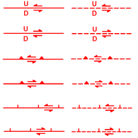

| Solid | Dashed | |
| Left-lateral High-Angle | lftHiAngFlt1.qry | lftHiAngFlt2.qry |
| Right-lateral High-Angle | rtHiAngFlt1.qry | rtHiAngFlt2.qry |
| Left-lateral Transpressional | lftTransPres1.qry lftTransPres1c.qry |
lftTransPres2.qry lftTransPres2c.qry |
| Right-Lateral Transpressional | rtTransPres1.qry rtTransPres1c.qry |
rtTransPres2.qry rtTransPres2c.qry |
| Left-lateral Transtensional | lftTransTen1.qry lftTransTen1c.qry |
lftTransTen2.qry lftTransTen2c.qry |
| Right-Lateral Transtensional | rtTransTen1.qry rtTransTen1c.qry |
rtTransTen2.qry rtTransTen2c.qry |
Geotectonic Map Symbols
 download geotectonic.zip
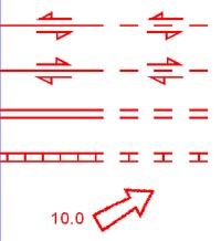
| Solid | Dashed | ||
| Left-Lateral Transform | trnfltl1.qry | trnfltl2.qry | |
| Right-Lateral Transform | trnfltr1.qry | trnfltr2.qry | |
| Spreading Axis or Ridge | ridge1.qry | ridge2.qry | |
| Suture | suture1.qry | suture2.qry | |
| Plate Motion Direction
and Rate |
arrow.qry | ||
Point Symbols for Attitude of Outcrop Features
Strike and Dip of Planar Features
 download planar.zip
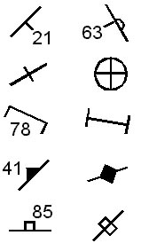
| Bedding: inclined,
overturned, vertical, horizontal |
bedding.qry |
| Cleavage: inclined, vertical | cleavage.qry |
| Foliation: inclined, vertical | foliatn.qry |
| Joint: inclined, vertical | joint.qry |
Trend and Plunge of Linear Features
 download linear.zip

| Mineral Lineation | lineatn.qry |
| Intersection Lineation | intrsect.qry |
| Minor Fold Axis | minfold.qry |
| Crenulation Axis | crenaxis.qry |